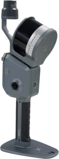
The compact handheld 3D scanner XGRIDS Lixel L2 Pro combines 360° LiDAR, 2× 48 MP panoramic cameras, and an IMU into one device for fast, accurate, and color 3D scanning both outdoors and indoors. Thanks to SLAM and AI, it generates a real-time point cloud without the need for post-processing, can scan even without RTK/GPS, and delivers accuracy up to ±3 cm. With the Lixel GO app and Lixel Studio 3.0 software, you get an efficient workflow from scan to export.
True colors and accuracy without RTK/GPS
With dual 48 MP panoramic cameras and stable Multi‑SLAM, the L2 Pro delivers faithful colors and ±3 cm accuracy even without RTK—ideal for interiors, tunnels, and forests.
Fast scanning and dense point cloud
Up to 640,000 pts/s, 120 m range, and LixelUpSample for resolution up to 1 mm with a layer thickness of 0.5 cm. Data is instantly available in .las format.
Mobility and durability for field work
Weight around 1.6–1.7 kg, 1.5‑hour runtime, 1 TB SSD, USB 3.1 Gen2, Wi‑Fi/Bluetooth, and IP54 rating—ready for dust and light rain.
Looking for a mobile 3D scanner that saves time while meeting accuracy demands? XGRIDS Lixel L2 Pro offers a range up to 120 m, speed up to 640,000 pts/s, and faithful RGB texturing right in the field. Thanks to the Multi‑SLAM algorithm, it reliably maps without GPS signal—in tunnels, forests, and buildings.
The patented LixelUpSample increases point cloud density to 1 mm with a layer thickness of 0.5 cm for detailed and consistent measurements. Built‑in 1 TB SSD storage, Wi‑Fi/Bluetooth, and 90‑minute runtime let you work without compromise. Files are saved in .las format and are ready for immediate use.
Suitable for:
- architecture, BIM, and construction inspections
- surveying and digital twins
- VR/AR visualization and asset capture
Specifications
- Manufacturer
- XGRIDS
- Weight
- 1.7 kg
- Dimensions
- 180 × 130 × 400 mm
- Power consumption
- < 30 W
- Interface
- USB 3.1 Gen2
- Internal storage
- 1 TB SSD
- Operating time
- 1.5 h
- Wireless connectivity
- Wi‑Fi, Bluetooth
- Operating temperature
- -20 °C to 50 °C
- Ingress protection
- IP54
- Video recording
- Yes
- Real-time RGB
- Yes
- Real-time RTK fusion
- Yes
- Point cloud formats
- .las (app output), .ply; vendor log “.forest .ply”
- Photo format
- .jpg
- Real-time accuracy (vertical, RMSE)
- 3 cm
- Real-time accuracy (horizontal, RMSE)
- 3 m
- Real-time accuracy (relative, RMSE)
- 2 cm
- Post-processed accuracy (vertical, RMSE)
- 3 cm
- Post-processed accuracy (absolute horizontal)
- 3 cm
- Post-processed accuracy (relative, RMSE)
- 1 cm
- Post-processed accuracy (repeatability, RMSE)
- 2 cm
- Point cloud layer thickness
- 0.5 cm
- Horizontal with RTK
- 0.015°
- Vertical
- 0.03°
- LixelUpSample
- Yes
- LiDAR – operating range
- 0.5 m to 120 m; up to 300 m (selected modes)
- LiDAR – class / wavelength
- Class 1 / 905 nm
- LiDAR – scan rate
- 320,000 pts/s; 640,000 pts/s
- LiDAR – sensor FOV
- 360° × 270°
- Panoramic cameras – resolution
- 2 × 48 MP
- Focal length
- 2 mm
- Aperture
- F/2.0
- CMOS
- 1/2"
- Shutter type
- Rolling Shutter
- Camera FOV
- 190° × 190°
- Battery – voltage
- 14.4 V
- Battery – capacity
- 46.8 Wh
- Charging – input
- 100–240 V, 50–60 Hz, 1.5 A, 80 VA
- Charging – output
- 16.8 V, 2.0 A
- Charging – power
- 34 W
- Box contents
- Lixel L2 Pro handheld scanner, Lixel Studio perpetual license (3 devices), L2 Pro battery, charger and adapter, USB‑C cable, GCP board, manual, warranty card, cleaning cloth, case